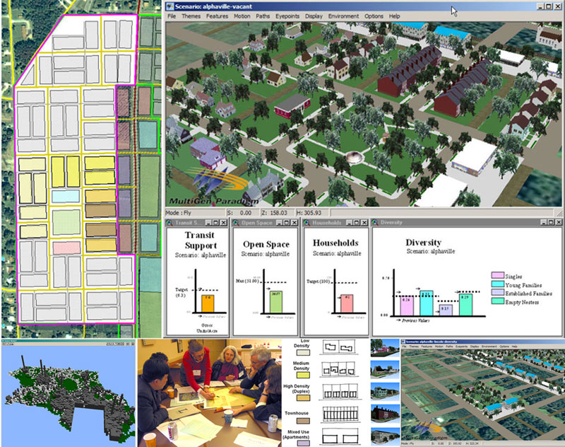
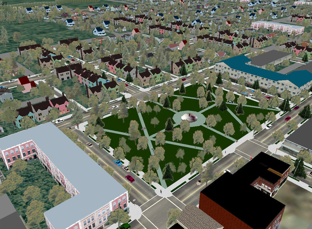
Lincoln Institute of Land Policy

Visioning and Visualization Workshop

The Lincoln Institute of Land Policy, whose mission includes "integrating theory and practice to better shape land policy" and "improving the quality of debate and disseminating knowledge of critical issues in land policy," invited the Environmental Simulation Center and ACP Visioning and Planning to develop a workshop for professional planners on "Visioning and Visualization.

Read more

Prince George's County

The Maryland-National Capital Park and Planning Commission (M-NCPPC) and the Prince George's County Planning Department, recognizing the value of 3D modeling and Planning Decision Support Systems (PDSS) as well as the challenges involved with institutionalizing the use of these tools in the county's planning process, issued an RFP for a "Plan for Capacity Building Using 3D & Modeling Applications"

Read more

Human Development Overlay District (HD-OD)

The Environmental Simulation Center (ESC) received a three-year grant from the Ford Foundation to develop the Human Development Overlay District (HD-ODTM).  This initiative will harness emerging information technologies to connect the often fragmented social service and physical planning processes in neighborhoods undergoing rapid change due to catalytic development projects. 

Read more

City of Glen Cove, New York

Examples of a build-out of a site under two different densities and zoning districts from the same viewpoint.

“There will be no more squinting and straining and imagining. Everyone will be able to see the same thing at the same time.” (Mayor Ralph Suozzi, Newsday 31 January 2010)

Read more

Preserving Sunlight in NYC's Parks

This project was conducted for The Parks Council, New York City and addresses the need for simple and easily administered regulatory controls to prevent the environmental degradation of the city’s inventory of parks at a time when resources are scant and it is urgent to extend to the greatest degree possible the use of parks we already have.

Read more

Long Island City

In response to the severe lack of office space in Manhattan and the surrounding boroughs, the Environmental Simulation Center, in partnership with the Regional Plan Association, Thompson Design, and Jonathon Rose Companies, developed proposals to create the City's fourth Regional Center in Long Island City. The proposal built on a prior study done with Robert B. Pauls for the LIC/LDC that proposed a Regional Center of approximately 20-24 million SF.
Read more

Houston - Performance, Tracking, and Allocation

Under a grant from the Transportation and Community and System Preservation (TCSP), the City of Houston engaged the ESC to develop a land development model and performance tracking system to monitor growth along the City's Main Street Corridor. The goals of the system were threefold: 1) provide a system that measures the performance of the corridor with regards to community goals and values; 2) track change as it occurs, and 3) allocate future-year growth to where it is likely to occur. The system, dubbed the Performance/ Tracking/Allocation (P/T/A) system, consists of two parts: the P/T/A Land Development Model and the P/T/A Performance Report Card.

Read more

John Jay College Condemnation Trial

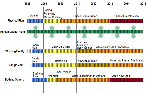
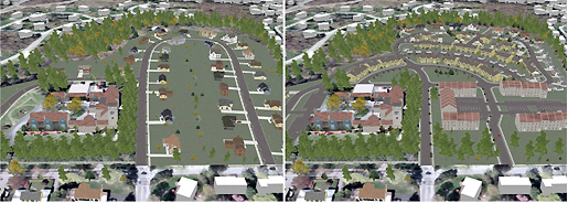
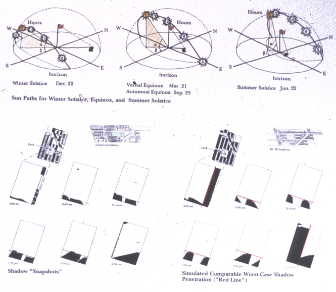
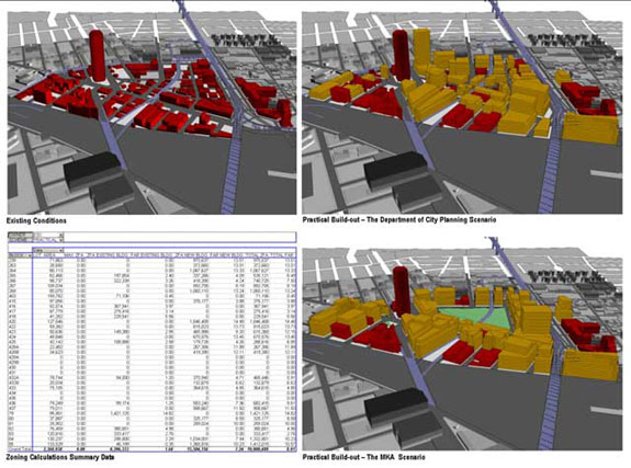
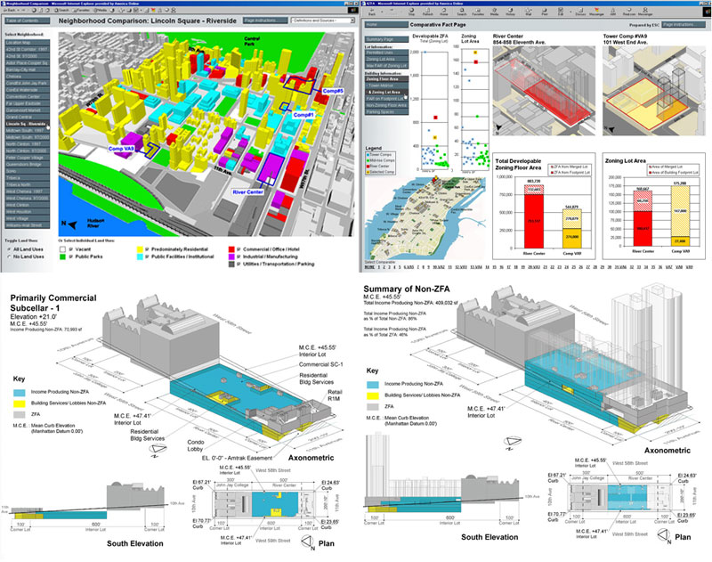
Prepared as evidence for a legal proceeding, the ESC developed an HTML presentation that detailed a huge amount of information visually, intuitively and completely directed by the user. 

The materials were designed to support a condemnation proceeding and were prepared to show how a single property compared to 39 other properties based on dozens of variables including items ranging from the floor area to the character of the neighborhood.  Because the materials would be used by a wide audience, including both professionals and novices, the ESC chose HTML and Java technologies that required users to have very basic requirements (Internet Explorer and Windows) to view and explore at their own pace and direction. 

Read more

Hudson Yards Rezoning

In order to support anticipated population growth and to position New York City as an office center in the 21st Century, the City undertook a comprehensive planning and zoning of West Midtown. The area under study is delineated by 29th Street to the South, 42nd Street to the North, Seventh Avenue / Herald Square to the East, and the Hudson River. The Eastern Portion is the densely developed Garment / Fashion while the Western Portion includes low density industrial uses, scattered housing, railyards and the Javits Convention Center.

Read more

Midtown Zoning - Regulatory Design

In 1980, the Chairman of the City Planning Commission in New York created a special task force to reevaluate the zoning regulations for Midtown that had been in place since 1961. Its main goal was to review the environmental impact that the discretionary review process had produced, especially concerning the amount of available daylight to streets, parks, plazas, and task lighting for office buildings, and propose as-of-right zoning regulations that would substitute for the uncertainties associated with discretionary zoning.

Read more

Kona - Community Development Plan

The ESC, along with ACP Visioning and Planning and Wilson Okamoto Associates, was selected to produce a Community Development Plan (CDP) for North and South Kona on the Big Island of Hawaii.  The CDP takes the County's General Plan and recommends specific locations and guidelines for growth, as well as capital improvement recommendations and a sustainable "green infrastructure" plan that creates ecological and cultural linkages across the landscape.

Read more